


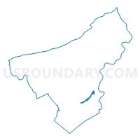
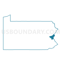
EASTON WD 12, Northampton County, Pennsylvania
About
Outline

Summary
| Unique Area Identifier | 661699 |
| Name | EASTON WD 12 |
| County | Northampton County |
| State | Pennsylvania |
| Area (square miles) | 0.95 |
| Land Area (square miles) | 0.65 |
| Water Area (square miles) | 0.30 |
| % of Land Area | 68.11 |
| % of Water Area | 31.89 |
| Latitude of the Internal Point | 40.67832860 |
| Longtitude of the Internal Point | -75.22887380 |
Maps

Graphs
Select a template below for downloading or customizing gragh for EASTON WD 12, Northampton County, Pennsylvania


Neighbors
Neighoring Voting District (by Name) Neighboring Voting District on the Map
- BETHLEHEM TWP WD 04 DIST 03, Northampton County, PA
- EASTON WD 07, Northampton County, PA
- EASTON WD 11, Northampton County, PA
- GLENDON Voting District, Northampton County, PA
- LOWER SAUCON TWP VTD 05 SHIMERSVILLE, Northampton County, PA
- PALMER TWP VTD EASTERN, Northampton County, PA
- PALMER TWP VTD WESTERN ED 01, Northampton County, PA
- WEST EASTON Voting District, Northampton County, PA
- WILLIAMS TWP VTD MIDDLE, Northampton County, PA
- WILLIAMS TWP VTD UPPER, Northampton County, PA
- WILSON WD 03, Northampton County, PA
Top 10 Neighboring County Subdivision (by Population) Neighboring County Subdivision on the Map
- Easton city, Northampton County, PA (26,800)
- Bethlehem township, Northampton County, PA (23,730)
- Palmer township, Northampton County, PA (20,691)
- Lower Saucon township, Northampton County, PA (10,772)
- Wilson borough, Northampton County, PA (7,896)
- Williams township, Northampton County, PA (5,884)
- West Easton borough, Northampton County, PA (1,257)
- Glendon borough, Northampton County, PA (440)
Top 10 Neighboring Place (by Population) Neighboring Place on the Map
- Easton city, PA (26,800)
- Wilson borough, PA (7,896)
- West Easton borough, PA (1,257)
- Glendon borough, PA (440)
Top 10 Neighboring Unified School District (by Population) Neighboring Unified School District on the Map
- Bethlehem Area School District, PA (116,811)
- Easton Area School District, PA (63,870)
- Saucon Valley School District, PA (16,670)
- Wilson Area School District, PA (15,477)
Top 10 Neighboring State Legislative District Lower Chamber (by Population) Neighboring State Legislative District Lower Chamber on the Map
- State House District 137, PA (72,979)
- State House District 138, PA (68,208)
- State House District 136, PA (63,631)
Top 10 Neighboring State Legislative District Upper Chamber (by Population) Neighboring State Legislative District Upper Chamber on the Map
Top 10 Neighboring 111th Congressional District (by Population) Neighboring 111th Congressional District on the Map
Top 10 Neighboring Census Tract (by Population) Neighboring Census Tract on the Map
- Census Tract 176.07, Northampton County, PA (6,602)
- Census Tract 181, Northampton County, PA (6,324)
- Census Tract 142, Northampton County, PA (6,029)
- Census Tract 175.02, Northampton County, PA (4,914)
- Census Tract 180.01, Northampton County, PA (4,086)
- Census Tract 146, Northampton County, PA (3,076)
- Census Tract 173, Northampton County, PA (2,560)
- Census Tract 147, Northampton County, PA (2,522)